Register Register Member Login Member Login Member Login Forgot Password ??
PHP , ASP , ASP.NET, VB.NET, C#, Java , jQuery , Android , iOS , Windows Phone
 

Registered : 109,027

HOME > Google Maps APIs สอนวิธีการใช้ Maps ของ Google เพื่อเรียกใช้งานแผนที่และแสดงผลบนเว็บไซต์ > ตอนที่ 4 : Google Maps API การสร้าง Custom Maps Style กำหนดรูปแบบของแผนที่


Clound SSD Virtual Server

ตอนที่ 4 : Google Maps API การสร้าง Custom Maps Style กำหนดรูปแบบของแผนที่

Google Maps API การสร้าง Custom Maps Style กำหนดรูปแบบของแผนที่ นอกจาก Map Type ที่ทาง Google Map API มีมาให้แล้ว เรายังสามารถสร้าง Map Type ในรูปแบบของ Custom Style ซึ่งจะสามารถกำหนดรูปแบบลักษณะของพื่นผิวและประเภทของการแสดงผล ได้ เช่น สักษณะของ แผนดิน , แม่น้ำ , ภูเขา เป็นต้น


Google Maps API Custom Map Style


รูปแบบการสร้าง Map Style
        var styledMapType = new google.maps.StyledMapType(
            [
              {elementType: 'geometry', stylers: [{color: '#ebe3cd'}]},
              {elementType: 'labels.text.fill', stylers: [{color: '#523735'}]},
              {elementType: 'labels.text.stroke', stylers: [{color: '#f5f1e6'}]},
              {
                featureType: 'administrative',
                elementType: 'geometry.stroke',
                stylers: [{color: '#c9b2a6'}]
              }
            ],
            {name: 'New Styled Map'});
เมื่อได้ New Style แล้วก็ให้ Add ลง Map ได้เลย
        map.mapTypes.set('styled_map', styledMapType);
        map.setMapTypeId('styled_map');


Ex : การทำ Custom Map Style เพื่อกำหนดลักษณะพื้นผิวของแผนที่

<!DOCTYPE html>
<html>
  <head>
    <title>Simple Map</title>
    <meta name="viewport" content="initial-scale=1.0">
    <script src="http://code.jquery.com/jquery-latest.min.js"></script>
    <meta charset="utf-8">
    <style>
      /* Always set the map height explicitly to define the size of the div
       * element that contains the map. */
      #map {
        height: 100%;
      }
      /* Optional: Makes the sample page fill the window. */
      html {
        height: 100%;
        margin: 0;
        padding: 0;
		text-align: center;
      }

      #map {
        height: 500px;
        width: 600px;
      }
    </style>
  </head>
  <body>
    <div id="map"></div>
    <script>
      function initMap() {

        // Create a new StyledMapType object, passing it an array of styles,
        // and the name to be displayed on the map type control.
        var styledMapType = new google.maps.StyledMapType(
            [
              {elementType: 'geometry', stylers: [{color: '#ebe3cd'}]},
              {elementType: 'labels.text.fill', stylers: [{color: '#523735'}]},
              {elementType: 'labels.text.stroke', stylers: [{color: '#f5f1e6'}]},
              {
                featureType: 'administrative',
                elementType: 'geometry.stroke',
                stylers: [{color: '#c9b2a6'}]
              },
              {
                featureType: 'administrative.land_parcel',
                elementType: 'geometry.stroke',
                stylers: [{color: '#dcd2be'}]
              },
              {
                featureType: 'administrative.land_parcel',
                elementType: 'labels.text.fill',
                stylers: [{color: '#ae9e90'}]
              },
              {
                featureType: 'landscape.natural',
                elementType: 'geometry',
                stylers: [{color: '#dfd2ae'}]
              },
              {
                featureType: 'poi',
                elementType: 'geometry',
                stylers: [{color: '#dfd2ae'}]
              },
              {
                featureType: 'poi',
                elementType: 'labels.text.fill',
                stylers: [{color: '#93817c'}]
              },
              {
                featureType: 'poi.park',
                elementType: 'geometry.fill',
                stylers: [{color: '#a5b076'}]
              },
              {
                featureType: 'poi.park',
                elementType: 'labels.text.fill',
                stylers: [{color: '#447530'}]
              },
              {
                featureType: 'road',
                elementType: 'geometry',
                stylers: [{color: '#f5f1e6'}]
              },
              {
                featureType: 'road.arterial',
                elementType: 'geometry',
                stylers: [{color: '#fdfcf8'}]
              },
              {
                featureType: 'road.highway',
                elementType: 'geometry',
                stylers: [{color: '#f8c967'}]
              },
              {
                featureType: 'road.highway',
                elementType: 'geometry.stroke',
                stylers: [{color: '#e9bc62'}]
              },
              {
                featureType: 'road.highway.controlled_access',
                elementType: 'geometry',
                stylers: [{color: '#e98d58'}]
              },
              {
                featureType: 'road.highway.controlled_access',
                elementType: 'geometry.stroke',
                stylers: [{color: '#db8555'}]
              },
              {
                featureType: 'road.local',
                elementType: 'labels.text.fill',
                stylers: [{color: '#806b63'}]
              },
              {
                featureType: 'transit.line',
                elementType: 'geometry',
                stylers: [{color: '#dfd2ae'}]
              },
              {
                featureType: 'transit.line',
                elementType: 'labels.text.fill',
                stylers: [{color: '#8f7d77'}]
              },
              {
                featureType: 'transit.line',
                elementType: 'labels.text.stroke',
                stylers: [{color: '#ebe3cd'}]
              },
              {
                featureType: 'transit.station',
                elementType: 'geometry',
                stylers: [{color: '#dfd2ae'}]
              },
              {
                featureType: 'water',
                elementType: 'geometry.fill',
                stylers: [{color: '#b9d3c2'}]
              },
              {
                featureType: 'water',
                elementType: 'labels.text.fill',
                stylers: [{color: '#92998d'}]
              }
            ],
            {name: 'New Styled Map'});

        // Create a map object, and include the MapTypeId to add
        // to the map type control.
        var map = new google.maps.Map(document.getElementById('map'), {
          center: {lat: 55.647, lng: 37.581},
          zoom: 11,
          mapTypeControlOptions: {
            mapTypeIds: ['roadmap', 'satellite', 'hybrid', 'terrain',
                    'styled_map']
          }
        });

        //Associate the styled map with the MapTypeId and set it to display.
        map.mapTypes.set('styled_map', styledMapType);
        map.setMapTypeId('styled_map');
      }
    </script>
    <script async defer
    src="https://maps.googleapis.com/maps/api/js?key=AIzaSyAK3RgqSLy1toc4lkh2JVFQ5ipuRB106vU&callback=initMap">
    </script>
  </body>
</html>

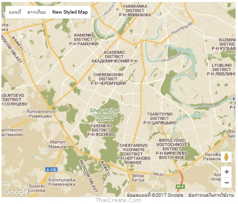
ผลลัพธ์ที่ได้จาก Custom Style


ซึ่งจะมี Control แสดงขึ้นมาเพื่อให้เลือกเปลี่ยน Map Style หรือ Map Type ได้


Share


ช่วยกันสนับสนุนรักษาเว็บไซต์ความรู้แห่งนี้ไว้ด้วยการสนับสนุน Source Code 2.0 ของทีมงานไทยครีเอท


ลองใช้ค้นหาข้อมูล


Bookmark.   
       
  By : ThaiCreate.Com Team (บทความเป็นลิขสิทธิ์ของเว็บไทยครีเอทห้ามนำเผยแพร่ ณ เว็บไซต์อื่น ๆ)
  Score Rating :  
  Create/Update Date : 2017-04-08 21:58:39 / 2017-04-09 07:01:19
  Download : No files
 Sponsored Links / Related

 
ตอนที่ 1 : Google Maps API (JavaScript) เบื้องต้นกับการใช้งานแผนที่บนของกูเกิลแมพ (Step by Step)
Rating :

 
ตอนที่ 2 : Google Maps API การเปิด-ปิด Control ต่างๆ ที่อยู่บนหน้า Maps แผนที่
Rating :

 
ตอนที่ 3 : Google Maps API การแสดงมุมมองของแผนที่ต่างๆ เช่น Zoom , Map Type
Rating :

 
ตอนที่ 5 : Google Maps API การปักหมุด (Marker) บนแผนที่ จาก Lat,Lon และรายละเอียด
Rating :

 
ตอนที่ 6 : Google Maps API การปักหมุด (Marker) หลายตำแหน่งจากข้อมูลชุด Array
Rating :

 
ตอนที่ 7 : Google Maps API การปักหมุด (Marker) หลายตำแหน่งจากข้อมูลชุด Json Object
Rating :

 
ตอนที่ 8 : Google Maps API Geolocation การอ่านและโฟกัสตำแหน่ง Location ปัจจุบัน
Rating :

 
ตอนที่ 9 : Google Maps API Geocoding การค้นหาระบุตำแหน่ง Location บนแผนที่
Rating :

 
ตอนที่ 10 : Google Maps API การปักหมุด (Marker) บนแผนที่ จาก PHP/MySQL (Json)
Rating :


ThaiCreate.Com Forum


Comunity Forum Free Web Script
Jobs Freelance Free Uploads
Free Web Hosting Free Tools

สอน PHP ผ่าน Youtube ฟรี
สอน Android การเขียนโปรแกรม Android
สอน Windows Phone การเขียนโปรแกรม Windows Phone 7 และ 8
สอน iOS การเขียนโปรแกรม iPhone, iPad
สอน Java การเขียนโปรแกรม ภาษา Java
สอน Java GUI การเขียนโปรแกรม ภาษา Java GUI
สอน JSP การเขียนโปรแกรม ภาษา Java
สอน jQuery การเขียนโปรแกรม ภาษา jQuery
สอน .Net การเขียนโปรแกรม ภาษา .Net
Free Tutorial
สอน Google Maps Api
สอน Windows Service
สอน Entity Framework
สอน Android
สอน Java เขียน Java
Java GUI Swing
สอน JSP (Web App)
iOS (iPhone,iPad)
Windows Phone
Windows Azure
Windows Store
Laravel Framework
Yii PHP Framework
สอน jQuery
สอน jQuery กับ Ajax
สอน PHP OOP (Vdo)
Ajax Tutorials
SQL Tutorials
สอน SQL (Part 2)
JavaScript Tutorial
Javascript Tips
VBScript Tutorial
VBScript Validation
Microsoft Access
MySQL Tutorials
-- Stored Procedure
MariaDB Database
SQL Server Tutorial
SQL Server 2005
SQL Server 2008
SQL Server 2012
-- Stored Procedure
Oracle Database
-- Stored Procedure
SVN (Subversion)
แนวทางการทำ SEO
ปรับแต่งเว็บให้โหลดเร็ว


Hit Link


Load balance : Server 04
ThaiCreate.Com Logo
© www.ThaiCreate.Com. 2003-2024 All Rights Reserved.
ไทยครีเอทบริการ จัดทำดูแลแก้ไข Web Application ทุกรูปแบบ (PHP, .Net Application, VB.Net, C#)
[Conditions Privacy Statement] ติดต่อโฆษณา 081-987-6107 อัตราราคา คลิกที่นี่